 |
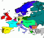
This is a map of New Europa. I like the maps in the other Falkenstein books, but they do not make national boundaries clear. This is my attempt to make things a little clearer. Though it is hampered by my poor artistic skills, I hope it gives a rough idea. Though most of the information on this site is based on the year 1875, this map is more accurate for 1878; particularly with regard to the Balkans. It might also be noticed that Schleswig and Holstein are not shown as being part of Prussia. I have assumed here that, since the Prussians lost the Seven Weeks War, Bismarck was unable to gain complete control of these regions.
|
 |
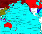
This is my map of colonialism in and around the Pacific. Astute readers will note that my attribution of colonial rulers to specific islands is not always historically accurate. Largely, this is because I drew this map as part of a game which assumed a Pacific overcrowded with voracious colonising powers. If this doesn't suit your game, you should of course feel free to change any or all of it.
|
 |
This one is a sort of general world map, showing the major powers, and world colonisation. Obviously, it is a) frequently anachronistic and b) largely incomplete. The anachronisms are mostly deliberate, the incompleteness may be dealt with at a later stage.
|


